Tuesday, February 28, 2012
Sunday, February 26, 2012
Indian Antarctic Program
Indian research station Maitri, located on the ice-free and rocky base of the Schirmacher Oasis.
The Indian Antarctic Program is a multi-disciplinary, multi-institutional program under the control of the National Centre for Antarctic and Ocean Research, Ministry of Earth Sciences, Government of India. It was initiated in 1981 with the first Indian expedition to Antarctica.[1] The program gained global acceptance with India's signing of the Antarctic Treaty and subsequent construction of the Dakshin Gangotri Antarctic research base in 1983,[1] superseded by the Maitri base from 1990. Under the program, atmospheric, biological, earth, chemical, and medical sciences are studied by India, which has carried out 30 scientific expeditions to the Antarctic as of 14th October 2010 and is currently planning to build an additional research station in the region named Bharathi and thus India is all set to join the elite group of nine countries which have multiple bases in Antarctica.
http://en.wikipedia.org/wiki/Indian_Antarctic_Program
Saturday, February 25, 2012
National Waterways of India

Inland Waterways Authority of India (Hindi: भारतीया अंतर्देशीय जलमार्ग प्राधिकरण) (IWAI) was created by Indian Government on 27 October 1986 for development and regulation of Inland Waterways for shipping and navigation. The Authority primarily undertakes projects for development and maintenance of Inland Waterway Terminal infrastructure on National Waterways through grant received from Ministry of Shipping, Road Transport and Highways. The head office is at Noida. The Authority also has its regional offices at Patna, Kolkata, Guwahati and Kochi and sub-offices at Allahabad,Varanasi, Bhagalpur, Farrakka and Kollam.
Operator: Central Inland Water Transport Corporation (CIWTC)
National Waterway 1
Allahabad–Haldia stretch of the Ganges–Bhagirathi–Hooghly river system.
Estd = October 1986.
Length = 1620 km
Fixed terminals = Haldia, BISN (Kolkata), Pakur, Farrakka and Patna.
Floating terminals = Haldia, Kolkata, Diamond Harbour, Katwa, Tribeni, Baharampur, Jangipur, Bhagalpur, Semaria, Doriganj, Ballia, Ghazipur,Varanasi, Chunar and Allahabad.
National Waterway 2
Sadiya — Dhubri stretch of Brahmaputra river.
Estd = September 1982.
Length = 891 km
Fixed terminals = Pandu.
Floating terminals = Dhubri, Jogighopa, Tezpur, Silghat, Dibrugarh, Jamgurhi, Bogibil, Saikhowa and Sadiya
National Waterway 3
Kottapuram-Kollam stretch of the West Coast Canal, Champakara Canal and Udyogmandal Canal.
Estd = February 1993
Length = 205 km
Fixed terminals = Aluva, Vaikom, Kayamkulam, Kottappuram, Maradu, Cherthala, Thrikkunnapuzha, Kollam and Alappuzha.
Floating terminals =
National Waterway 4
Kakinada–Pondicherry stretch of Canals and the Kaluvelly Tank, Bhadrachalam – Rajahmundry stretch of River Godavari and Wazirabad – Vijayawada stretch of River Krishna.
Estd = November 2008
Length = 1095 km
It was declared a National Waterway on 24 November 2008 under the Provisions of National Waterways Bill, 2006. It is being developed by the Inland Waterways Authority of India (IWAI) and is scheduled for completion in 2013.
National Waterway 5
Talcher–Dhamra stretch of the Brahmani River, the Geonkhali - Charbatia stretch of the East Coast Canal, the Charbatia–Dhamra stretch of Matai river and the Mangalgadi - Paradip stretch of the Mahanadi River Delta.
Established = November 2008
Length = 623 km
National Waterway 6
Lakhipur to Bhanga of river Barak.
Proposed
Length = 121 km
Development of NW-4, 5 & 6
As early as 1993-95, IWAI commenced studies for developing an integrated canal linking Kakinada and Chennai. The Indian government initiated the process for developing three more national waterways in 2005.[5] In July 2006, T. R. Baalu, the Minister of Shipping, Road Transport and Highways announced the proposal for development of NW-4 in the Lok Sabha.[6] In addition to the three existing national waterways, the government also declared the following inland waterways as national waterways:
Kakinada-Pondicherry canals along with Godavari and Krishna rivers (1,095 kilometres (680 mi)) as NW-4
East Coast Canal along with Brahmani river and Mahanadi delta (623 kilometres (387 mi)) as NW-5
River Barak (152 kilometres (94 mi)) as NW-6
The proposals were made into law with the passage of the Inland Vessels (Amendment) Bill, 2005 in 2007.[7] In October 2008, another bill - the National waterways Bill, 2006 - was passed in Parliament. It declared the Kakinada-Pondicherry stretch of canals comprising the Kakinada canal, Eluru canal, Commamur canal, Buckingham canal, the Kaluvelly tank, Bhadrachalam- Rajahmundry stretch of riversGodavari, Wazirabad-Vijayawada stretch of river Krishna in Andhra Pradesh, TamilNadu, andPondicherry as national waterways.[8] According to this bill, it will take five years and 542 crores (5.42 Billion) (in 2002 prices) for the completion of the proposed new national waterways.
Friday, February 24, 2012
Shale Gas
Shale is a fine-grained, clastic sedimentary rock composed of mud that is a mix of flakes of clay minerals and tiny fragments (silt-sized particles) of other minerals, especially quartz and calcite. The ratio of clay to other minerals is variable. Shale is characterized by breaks along thin laminae or parallel layering or bedding less than one centimeter in thickness, called fissility. Mudstones, on the other hand, are similar in composition but do not show the fissility(the property of rocks to split along planes of weakness into thin sheets).
Shale gas is natural gas produced from shale. Shale gas has become an increasingly important source of natural gas in the United States over the past decade, and interest has spread to potential gas shales in the rest of the world. One analyst expects shale gas to supply as much as half the natural gas production in North America by 2020
Because shales ordinarily have insufficient permeability to allow significant fluid flow to a well bore, most shales are not commercial sources of natural gas. Shale gas is one of a number of unconventional sources of natural gas; other unconventional sources of natural gas include coalbed methane, tight sandstones, and methane hydrates. Shale gas areas are often known as resource plays (as opposed to exploration plays). The geological risk of not finding gas is low in resource plays, but the potential profits per successful well are usually also lower.
National Water Policy
In the planning and operation of systems, water allocation priorities should be broadly as follows:
· Drinking water
· Irrigation
· Hydro-power
· Ecology
· Agro-industries and non-agricultural industries
· Navigation and other uses.
Thursday, February 23, 2012
Passes in India
| Name | State | Height (ft) |
| Khardung La | Jammu and Kashmir | 18380 |
| Marsimik La | Jammu and Kashmir | 18314 |
| Nama Pass | Uttarakhand | 18045 |
| Sin La | Uttarakhand | 18028 |
| Changla Pass | Jammu and Kashmir | 17800 |
| Sasser Pass | Jammu and Kashmir | 17753 |
| Tanglang La | Jammu and Kashmir | 17583 |
| Debsa Pass | Himachal Pradesh | 17520 |
| Lamkhaga Pass | Himachal Pradesh | 17336 |
| Traill's Pass | Uttarakhand | 17100 |
| Lungalacha La | Jammu and Kashmir | 16600 |
| Bara-lacha-la | Himachal Pradesh | 16400 |
| Goecha La | Sikkim | 16207 |
| Kunjum Pass | Himachal Pradesh | 14931 |
| Indrahar Pass | Himachal Pradesh | 14473 |
| Jelep La | Sikkim | 14300 |
| Nathu La | Sikkim | 14140 |
| Sela Pass | Arunachal Pradesh | 14000 |
| Fotu La | Jammu and Kashmir | 13451 |
| Rohtang Pass | Himachal Pradesh | 13051 |
| Zojila Pass | Jammu and Kashmir | 12400 |
| Namika La | Jammu and Kashmir | 12139 |
| Dongkhala | Sikkim | 12000 |
| Banihal Pass | Jammu and Kashmir | 9291 |
| Palakkad Gap | Kerala | 1000 |
| Asirgarh | Madhya Pradesh | |
| Mayali Pass | ||
| Dhumdhar Kandi Pass | ||
| Haldighati | Rajasthan | |
| India |
Wednesday, February 22, 2012
EF Scale
The Enhanced Fujita Scale (EF Scale) rates the strength of tornadoes in the United States based on the damage they cause.
Thursday, February 16, 2012
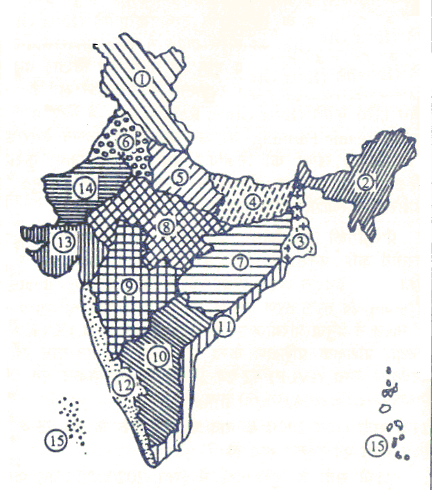
Agro-ecological Regions of India
AGRO -ECOLOGICAL REGIONS OF
INDIA
Another classification that is
relevant in understanding the cropping patterns and agricultural practices of
the country is that based on the ecological features of different regions. This
classification also takes into account the period for which crops can be grown
naturally in the region. The classification is given below:
Arid Ecosystem
1. Western Himalayas, cold arid
ecoregion, with shallow skeletal soils & length of Growing Period (GP)
<90 days
2. Western Plain, Kachchh and
part of Kathiawar Peninsula , hot arid ecoregion, with desert & saline
soils & GP <90 days
3. Deccan Plateau, hot arid
ecoregion, with Red & Black soils & GP <90 days
Semiarid Ecosystem
4. Northern Plain and Central
Highlands including Aravallis, hot semi-arid ecoregion, with Alluvium derived
soils & GP 90-150 days
5. Central (Malwa) Highlands,
Gujarat Plains & Kathiawar Peninsula , hot semi-arid ecoregion, with medium
& deep Black soils & GP 90-150 days
6. Deccan Plateau, hot
semi-arid ecoregion with shallow and medium (with inclusion of deep) Black
soils & GP 90-150 days
7. Deccan (Telangana) Plateau
and Eastern Ghats , hot semi-arid ecoregion, with Red & Black soils &
GP 90-150 days
8. Eastern Ghats , TN uplands
and Deccan (Karnataka) Plateau, hot semi-arid ecoregion with Red loamy soils
& GP 90-150 days
Subhumid Ecosystem
9. Northern Plain, hot subhumid
(dry) ecoregion, with Alluvium-derived soils & GP 150- 180 days
10. Central Highlands (Malwa,
Bundelkhand & Satputra), hot subhumid ecoregion, with Black and Red Soils
& GP 150-180 (to 210) days
11. Eastern Plateau
(Chhatisgarh), hot subhumid ecoregion, with Red & Yellow soils, & GP
150-180 days
12. Eastern (Chhotanagpur)
Plateau and Eastern Ghats , hot subhumid ecoregion, with Red & Lateritic
soils & GP 150-180 (to 210) days
13. Eastern Plain, hot subhumid
(moist) ecoregion, with Alluvium-derived soils & GP 180 - 210 days
14. Western Himalayas, warm
subhumid (to humid with inclusion of perhumid ecoregion with Brown forest and
Podzolic soils, & GP 180-210 + days
Humid-Perhumid
Ecosystem
15. Bengal and Assam Plain, hot
subhumid (moist) to humid (inclusion of perhumid) ecoregion, with Alluvium-derived
soils & GP 210 + days
16. Eastern Himalayas , warm
perhumid ecoregion, with Brown and Red hill soils, & GP 210 + days
17. North-eastern Hills
(Purvachal), warm perhumid ecoregion, with Red and Lateritic soils & GP 210
+ days . Coastal Ecosystem
18. Eastern Coastal Plain, hot
subhumid to semi-arid ecoregion, with Coastal Alluvium- derived soils & GP
90-210 + days
19. Western Ghats & Coastal
Plain, hot humid perhumid ecoregion, with Red, Lateritic and Alluvium- derived
soils and GP 219 + days
Island Ecosystem
20. Islands of Andaman-Nicobar
and Lakshadweeo hot humid to perhumid island ecoregion, with Red loamy and
Sandy soils and GP 210+ days
Agro-climatic Zones
The Platanning Commission of India (1989) has laid down following 4 objectives for agro-climatic regional planning : (a) Attempt a broad demand-supply balance of major commodities at the national level but based on a careful analysis of potential and prospects of various zones; (b) maximise net income of producers; (c) generate additional employment, particularly of landless labourers, and (d) provide the framework for the scientific and sustainable use of our natural resources, particularly land, water and forests, in the long run.
Taking above objectives in mind the Planning Commission (1989) has divided India into 15 major agro-climatic regions delineated on the basis of a commonality of agro-climatic factors like soil type, rainfall, temperature, water resources, etc.
In this innovative approach, based on agro-climatic zones, an overall development profile of each region is formulated through an optimal mix of land stock management, crop production, animal husbandry, aquaculture, horticulture, forestry and agro-processing activities.
The Planning Commission after examining the earlier studies on the regionalization of the agricultural economy has recommended that agricultural planning be done on the basis of agro climatic regions. For resource development, the country has been broadly divided into fifteen agricultural regions based on agro climatic features, particularly soil type, climate including temperature and rainfall and its variation and water resources availability as under:
1. Western Himalayan Region: J&K, HP, UP, Utranchal
2. Eastern Himalayan Region: Assam Sikkim, W.Bangal & all North-Eastern states
3. Lower Gangetic Plains Region: W.Bangal
4. Middle Gangetic Plains Region: UP, Bihar
5. Upper Gangetic Plains Region: UP
6. Trans-Gangetic Plains Region: Panjab, Haryana, Delhi & Rajasthan
7. Eastern Plateau and Hills Region: Maharastra, UP, Urissa & W.Bangal
8. Central Plateau and Hills Region: MP, Rajasthan, UP
9. Western Plateau and Hills Region: Maharastra, MP & Rajasthan
10. Southern Plateau and Hills Region: AP, Karnatak, Tamil Nadu
11. East Coast Plains and Hills Region: Urissa, AP, TN,& Pondicheri
12. West Coast Plains and Ghat Region : TN, Keral, Gowa, Karnatak, Maharastra
13. Gujarat Plains and Hills Region: Gujrat
14. Western Dry Region: Rajasthan
15. The Islands Region: Andman & Nicaobar, Lakshya Deep
Zonal Characterisation in the Form of Typologies
1. Rich water and soil resources, high land productivity (major crops), moderate VI population pressure on land.
2. Rich soil and water resources, medium productivity level and moderate population pressure on land, deteriorating environment with respect to land quality.
3. Rich water and soil resources, low productivity level, high population pressure on III & IV land, increasing proportion of problem soils.
4. Large volume of land and water resources, very low productivity of land with VII & VIII predominance of subsistence agriculture, low population pressure, high proportion of problem soils.
5. Less favourable soil and water resources, low and productivity, low to medium IX & X population pressure, deteriorating environment in respect of soil erosion and water quality.
6. Rich water resources but relatively poor land, medium land productivity, medium XI, XII to high population pressure, fragile eco-system. & XV
7. Less favourable land and water resources, low land productivity, low pressure on I & II land and fragile eco-system.
8. Semi-arid to arid conditions, moderately good land quality and productivity, mode- XIII rate population pressure on land.
9. Arid conditions, large but less fertile soil resources, very low land productivity, low XIV population pressure and fragile eco-system.
Tiger Reserves of India
There are 41 tiger reserves in India (21-6-2011) which are governed by Project Tiger which is administered by the National Tiger Conservation Authority.[1] There were an additional six proposed and four approved in principle reserves that are not yet declared.
Goals:
The 53,547 km2 (20,675 sq mi) of declared reserves are operated by state forestry departments “to ensure maintenance of viable populations of the conservation dependent Bengal tigers in India. The tigers are maintained for their scientific, economic, aesthetic, cultural and ecological values and to preserve for all time areas of biological importance as a national heritage for the benefit, education and enjoyment of the people”.
The largest Tiger Reserve is the 3,568 km2 (1,378 sq mi) Nagarjunsagar-Srisailam Tiger Reserve of Andhra Pradesh.
Population assessment:
The landmark 2008 report, Status of the Tigers, Co-predators, and Prey in India, published by the National Tiger Conservation Authority, estimated only 1411 adult tigers in existence in India (plus uncensused tigers in the Sundarbans).
The 2010 National Tiger Assessment estimated the total population of tigers in India as 1,706. This exhaustive study indicated that better protected tiger source sites, especially tiger reserves, have maintained viable tiger populations, however, the area occupied by tigers outside protected areas has decreased considerably. This demonstrates the need for securing corridors for tigers to move between source sites. The existing tiger reserves represent around one-third of India's high density forest area.
Management effectiveness
From June, 2010 to July, 2011 the National Tiger Conservation Authority (NTCA) in partnership with the Wildlife Institute of India (WII) undertook an independent Management Effectiveness Evaluation (MEE) of all 39 tiger reserves in the country. The category-wise outcome of MEE Process is summarized as follows:
Very Good:
Annamalai, Bandhavgarh, Bandipur, Bhadra, Dandeli-Anshi, Kalakad-Mundanthurai, Kanha, Kaziranga, Mudumalai, Parambikulam, Pench (Madhya Pradesh), Periyar, Satpura and Sundarbans
Good:
Buxa, Corbett, Dampa, Dudhwa, Manas, Melghat, Nagarhole, Pakke, Pench (Maharashtra), Ranthambhore and Tadoba-Andhari
Satisfactory:
Achanakmar, Nameri, Namdapha, Sanjay, Sayadari and Valmiki
Poor:
Satkosia
| State | Tiger Reserves | Year Estd. | Est. No. | Total Area (km2) | Management status | Remarks |
| Andhra Pradesh | Nagarjunsagar-Srisailam Tiger Reserve | 1982-83 | 14 | 3568 | poor | Low tiger densityLeft wing extremism(Naxalite) |
| Andhra Pradesh | Kawal Tiger Reserve | 2011-6-15ref | 42 | 893 | 20 tigers (2010) | |
| Arunachal Pradesh | Pakhui Tiger Reserve | 1999–2000 | 26 | 862 | good | Good tiger density |
| Arunachal Pradesh | Namdapha Tiger Reserve | 1982-83 | 15 | 1985 | satisfactory | Low tiger density, Extremism, encroachment byLisus |
| Assam | Manas Tiger Reserve | 1973-74 | 4 | 2840 | good | Poor tiger density, Recovering from prolonged disturbance due to Bodo unrest |
| Assam | Kaziranga Tiger Reserve | 2006 | 32 | 859 | very good | Good tiger density |
| Assam | Nameri Tiger Reserve | 1999–2000 | 27 | 344 | satisfactory | Encroachment and tree cutting by locals |
| Bihar | Valmiki Tiger Reserve | 1989-90 | 18 | 840 | satisfactory | Low tiger density extremism |
| Chhattisgarh | Guru Ghasidas National Park | 2010 (pro) | 51 | 2899 | satisfactory | Separated fromSanjay National Park in Madhya Pradesh |
| Chhattisgarh | Indravati Tiger Reserve | 1982-83 | 13 | 2799 | poor | Severely affected by Naxalites, Out of bounds |
| Chhattisgarh | Achanakmar Tiger Reserve[2] | 2008 | 33 | 963 | satisfactory | Low tiger density |
| Chhattisgarh | Udanti & Sitanadi Tiger Reserve | 2008-09 | 30 | 1580 | poor | Low tiger density |
| Goa | Mhadei Tiger Reserve | 2011 (pro) | 52 | [11] | ||
| Jharkhand | Palamau Tiger Reserve | 1973-74 | 6 | 1026 | Poor | Low tiger density, Left wing extremism |
| Karnataka | Bhadra Tiger Reserve | 1998-99 | 24 | 492 | very good | Low tiger density |
| Karnataka | Nagarhole (extension) Tiger Reserve | 1999–2000 | 37 | 643 | good | Good tiger density |
| Karnataka | Bandipur Tiger Reserve | 1973-74 | 1 | 866 | very good | Good tiger density |
| Karnataka | Dandeli-Anashi Tiger Reserve | 2007 | 34 | 875 | satisfactory | Low tiger density |
| Karnataka | Kudremukh Tiger Reserve | 2011 | 41 | 360[10] | 20 tigers (2010) | |
| Karnataka | Biligiri Rangaswamy Temple Wildlife Sanctuary | 2010 | 40 | 540 [3] | 17 tigers (2005) | |
| Karnataka | Bannerghatta tiger and lion reserve | 1978 | 104 | zoo | not a Project Tiger reserve | |
| Kerala | Periyar Tiger Reserve | 1978-79 | 10 | 925 | very good | There are an estimated 53 tigers(2010) in the reserve. |
| Kerala | Parambikulam Tiger Reserve | 2010 | 38 | 391 | very good | Moderate tiger density |
Biosphere Reserves of India
The Indian government has established 17 Biosphere Reserves of India, (categories roughly corresponding to IUCN Category V Protected areas), which protect larger areas of natural habitat (than a National Park or Animal Sanctuary), and often include one or more National Parks and/or preserves, along buffer zones that are open to some economic uses. Protection is granted not only to the flora and fauna of the protected region, but also to the human communities who inhabit these regions, and their ways of life.
Seven of the seventeen biosphere reserves are a part of the World Network of Biosphere Reserves, based on the UNESCO Man and the Biosphere (MAB) Programme list: (N3GPS2)
- Nilgiri Biosphere Reserve, 2000
- Gulf of Mannar Biosphere Reserve, 2001
- Sundarbans national park, 2001
- Nanda Devi Biosphere Reserve, 2004
- Nokrek Biosphere Reserve, 2009
- Pachmarhi Biosphere Reserve, 2009
- Simlipal Biosphere Reserve, 2009
The above two along with Manas Biosphere Reserve are among the 22 new sites recently added by UNESCO to its World Network of Biosphere Reserves. Their inclusion raises the number of Indian sites on the World list to seven, from a total of 15 Biosphere Reserves across the subcontinent. In 2009, India designated Cold Desert of Himachal Pradesh as a Biosphere Reserve. And on September 20th, 2010, Ministry of Environment and Forests designated Seshachalam Hills as another Biosphere Reserve taking the count to number of such designated areas to 17. Now, India has 17 Biosphere reserves.
| Name | Location | State | Type | Year | Area (km²) |
| Great Nicobar Biosphere Reserve | Southern most islands of Andaman and Nicobar Islands | Andaman and Nicobar Islands | Islands | 1989 | 885 |
| Seshachalam Hills | Seshachalam Hill Ranges covering parts of Chittoor and Kadapa districts | Andhra Pradesh | Eastern Ghats | 2010 | 4755.997 |
| Dehang-Dibang | Part of Siang and Dibang Valley | Arunachal Pradesh | East Himalayas | 1998 | 5112 |
| Manas | Part of Kokrajhar, Bongaigaon, Barpeta, Nalbari, Kamrup andDarrang Districts | Assam | East Himalayas | 1989 | 2837 |
| Dibru-Saikhowa | Part of Dibrugarh and Tinsukia districts | Assam | East Himalayas | 1997 | 765 |
| Great Rann of Kutch | Part of Kutch, Rajkot and Surendranagar Districts | Gujarat | Desert | 2008 | 12454 |
| Cold Desert | Pin Valley National Park and surroundings;Chandratal and Sarchu & Kibber Wildlife Sancturary | Himachal Pradesh | Western Himalayas | 2009 | 7770 |
| Agasthyamalai Biosphere Reserve | Neyyar, Peppara and Shenduruny Wildlife Sanctuary and their adjoining areas | Kerala, Tamil Nadu | Western ghats | 2001 | 1828 |
| Pachmarhi Biosphere Reserve | Parts of Betul District, Hoshangabad District and Chhindwara District | Madhya Pradesh | Semi-Arid | 1999 | 4926 |
| Achanakamar -Amarkantak | Part of Annupur, Dindori and Bilaspur districts | Madhya Pradesh,Chattisgarh | Maikala Range | 2005 | 3835 |
| Nokrek | Part of Garo Hills | Meghalaya | East Himalayas | 1988 | 820 |
| Simlipal | Part of Mayurbhanj district | Orissa | Deccan Peninsula | 1994 | 4374 |
| Khangchendzonga | Parts of Kanchanjunga Hills | Sikkim | East Himalayas | 2000 | 2620 |
| Gulf of Mannar | Indian part of Gulf of Mannar between India and Sri Lanka | Tamil Nadu | Coasts | 1989 | 10500 |
| Nilgiri Biosphere Reserve | Part of Waynad, Nagarhole, Bandipur and Mudumalai,Nilambur, Silent Valley and Siruvani Hills | Tamil Nadu, Keralaand Karnataka | Western Ghats | 1986 | 5520 |
| Nanda Devi | Parts of Chamoli District, Pithoragarh District & Bageshwar District | Uttarakhand | West Himalayas | 1988 | 5860 |
| Sunderbans | Part of delta of Ganges and Barahamaputra river system | West Bengal | Gangetic Delta | 1989 | 9630 |
Potential Sites for Biosphere Reserves
Following is the list of potential sites for Biosphere Reserves as selected by Ministry of Forests and Environment:-
- Namdapha, Arunachal Pradesh
- Thar desert, Rajasthan
- Little Rann of Kutch, Gujarat
- Kaziranga, Assam
- Kanha, Madhya Pradesh
- North Islands of Andaman Andaman & Nicobar
- Abujmarh, Madhya Pradesh
- Chintapalli, Andhra Pradesh
- Lakshadweep Islands, Lakshadweep
- Singbhum, Jharkhand
Subscribe to:
Posts (Atom)