The Platanning Commission of India (1989) has laid down following 4 objectives for agro-climatic regional planning : (a) Attempt a broad demand-supply balance of major commodities at the national level but based on a careful analysis of potential and prospects of various zones; (b) maximise net income of producers; (c) generate additional employment, particularly of landless labourers, and (d) provide the framework for the scientific and sustainable use of our natural resources, particularly land, water and forests, in the long run.
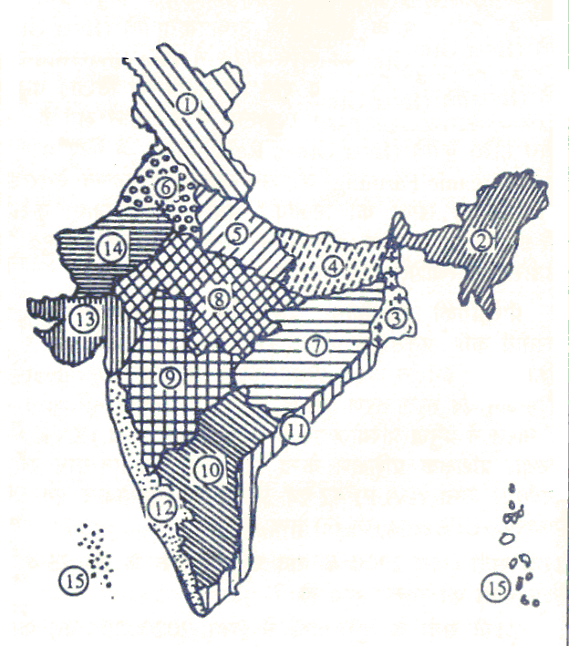
Taking above objectives in mind the Planning Commission (1989) has divided India into 15 major agro-climatic regions delineated on the basis of a commonality of agro-climatic factors like soil type, rainfall, temperature, water resources, etc.
In this innovative approach, based on agro-climatic zones, an overall development profile of each region is formulated through an optimal mix of land stock management, crop production, animal husbandry, aquaculture, horticulture, forestry and agro-processing activities.
The Planning Commission after examining the earlier studies on the regionalization of the agricultural economy has recommended that agricultural planning be done on the basis of agro climatic regions. For resource development, the country has been broadly divided into fifteen agricultural regions based on agro climatic features, particularly soil type, climate including temperature and rainfall and its variation and water resources availability as under:
1. Western Himalayan Region: J&K, HP, UP, Utranchal
2. Eastern Himalayan Region: Assam Sikkim, W.Bangal & all North-Eastern states
3. Lower Gangetic Plains Region: W.Bangal
4. Middle Gangetic Plains Region: UP, Bihar
5. Upper Gangetic Plains Region: UP
6. Trans-Gangetic Plains Region: Panjab, Haryana, Delhi & Rajasthan
7. Eastern Plateau and Hills Region: Maharastra, UP, Urissa & W.Bangal
8. Central Plateau and Hills Region: MP, Rajasthan, UP
9. Western Plateau and Hills Region: Maharastra, MP & Rajasthan
10. Southern Plateau and Hills Region: AP, Karnatak, Tamil Nadu
11. East Coast Plains and Hills Region: Urissa, AP, TN,& Pondicheri
12. West Coast Plains and Ghat Region : TN, Keral, Gowa, Karnatak, Maharastra
13. Gujarat Plains and Hills Region: Gujrat
14. Western Dry Region: Rajasthan
15. The Islands Region: Andman & Nicaobar, Lakshya Deep
Zonal Characterisation in the Form of Typologies
1. Rich water and soil resources, high land productivity (major crops), moderate VI population pressure on land.
2. Rich soil and water resources, medium productivity level and moderate population pressure on land, deteriorating environment with respect to land quality.
3. Rich water and soil resources, low productivity level, high population pressure on III & IV land, increasing proportion of problem soils.
4. Large volume of land and water resources, very low productivity of land with VII & VIII predominance of subsistence agriculture, low population pressure, high proportion of problem soils.
5. Less favourable soil and water resources, low and productivity, low to medium IX & X population pressure, deteriorating environment in respect of soil erosion and water quality.
6. Rich water resources but relatively poor land, medium land productivity, medium XI, XII to high population pressure, fragile eco-system. & XV
7. Less favourable land and water resources, low land productivity, low pressure on I & II land and fragile eco-system.
8. Semi-arid to arid conditions, moderately good land quality and productivity, mode- XIII rate population pressure on land.
9. Arid conditions, large but less fertile soil resources, very low land productivity, low XIV population pressure and fragile eco-system.
No comments:
Post a Comment